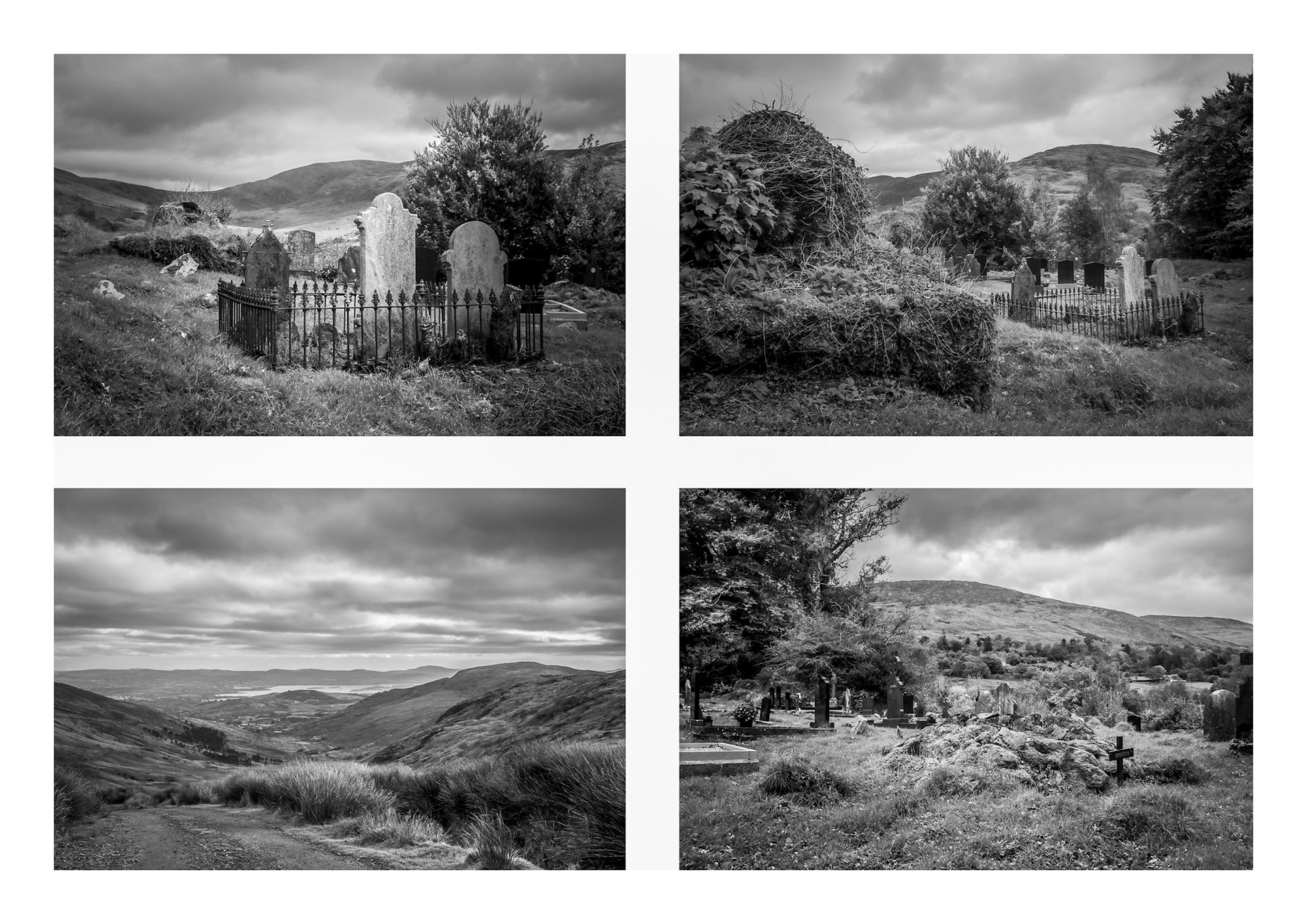
February 2026: Ireland’s history and souls resting peacefully in St Feaghna’s Burial Ground
The St Feaghna Burial Ground, set high in the mountains near Gurranes, Co Kerry on the “Priest’s Leap route”, is one of the oldest Christian burial sites still in use in Ireland. St. Feaghna, born in Kealkil, Co Cork and patron saint of the nearby village of Bonane, built a church at the graveyard.
The graveyard consists of an inner wall and an outer wall. The inner wall is a much older structure; possibly dating back to pre-Christian times. The outer wall was constructed during the time of the Great Famine in the 1840s as a relief project using labour of the starving people of this potato blight-ridden land. Graves, known as cilleanachs, lieing in the unhallowed ground between these two walls, hold suicide victims, un-baptised babies and still-births. These people could not be buried in consecrated ground at that time; reminding us of an era when harsh church rules governed its devout followers.
Even such a remote ancient graveyard is not far from the dramatic and often painful events in Irish history. The links between Irish Catholicism and the Ancient Celtic Religions; the effects of The Great Famine and the role of the British government in it; the often very harsh practices of the early Catholic Church; have all helped shaped this graveyard.
Nevertheless; the sheer tranquility of the graveyard’s setting must still provide comfort to local community. Knowing that their ancestors rest peacefully, as they might also rest eventually, in this beautiful and historic place must provide great solace.
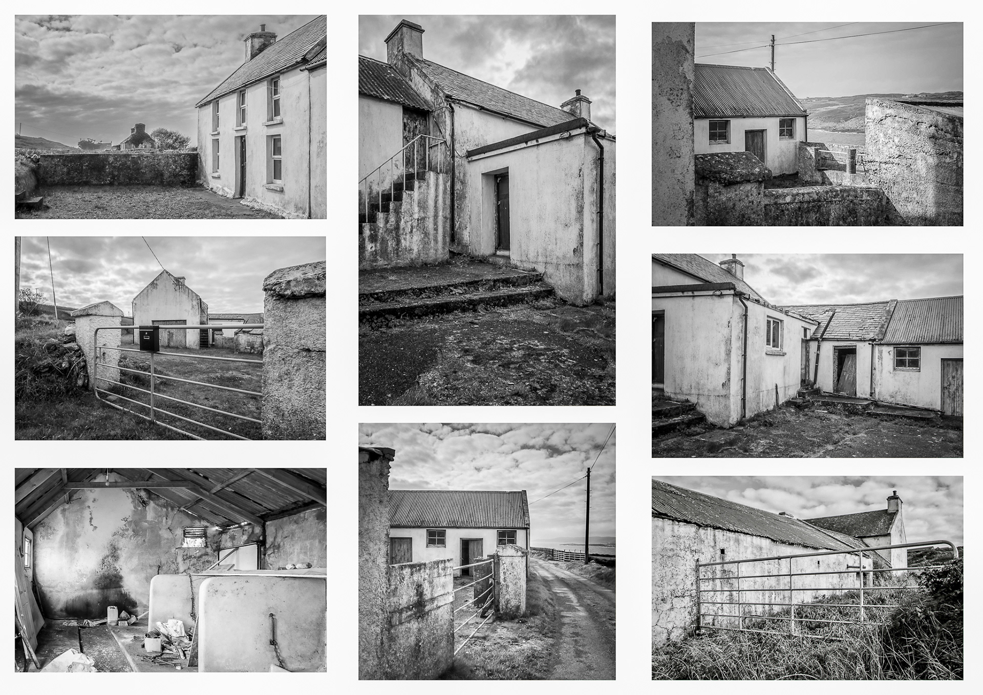
January 2026: Dairy farming in Ireland; an industry built on small intergenerational family-owned farms
There are approximately 16,000 family-owned dairy farms in Ireland. The average size of an Irish dairy farm is around 34 hectares and the average herd size is around 98 cows. The vast majority of Irish dairy output arises from these small family farms; they are the backbone of Ireland’s substantial dairy industry (2023/2024).
These photographs were taken on a trip to one to the incredibly scenic peninsulas in West Cork. The farmhouse shares some stone walls with the farm buildings; indicating just how intertwined family life and the family farm were.
Although work in these farm buildings had long ceased; they are not atypical of the many operating farms across remote Ireland. Each retains its uniqueness; not only in the details of their physical appearance, but, more importantly, in the stories they tell about the people who inhabit the wild terrains of West Cork and Ireland.
I posted some of these photos on Facebook and was delighted to receive comments from several people. They were all cousins whose parents had grown up in the farmhouse. Their parent’s generation, dating back to the early 20th century, comprised ten siblings. Many of their children still lived in the local area or were still involved in farming.
One should not romanticise rural life; it was and remains a tough life. But the people who contacted me had many happy memories. These farm buildings and the farmhouse may be old but the stories they could tell are timeless.
Although many of these stories are quite sad, they are part of the beauty of wilds of West Cork and Ireland.
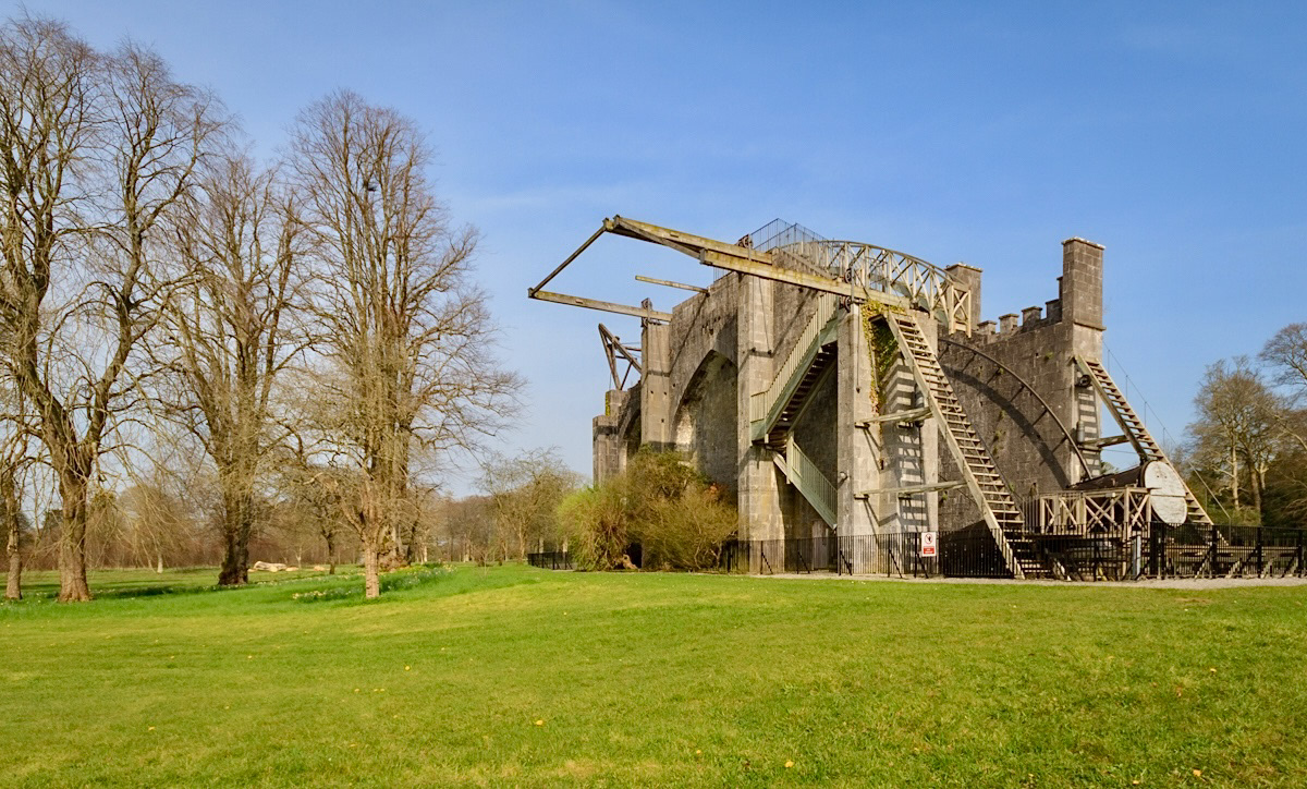
Week 12 (starting 29 December 2025): When Co Offaly was at the forefront of humanity’s efforts to understand the cosmos
In the early 1840’s, the Third Earl of Rosse designed and built the largest telescope in the world (known as The Leviathan of Parsonstown) in the grounds of the Birr Castle Demesne, Co Offaly. It was the largest telescope in the world from 1845-1917!
The purpose of the telescope was to decide if nebulae were merely unresolved star clusters or genuinely nebulous regions of space. With the telescope, they discovered that several nebulae had a spiral structure, suggesting the operation of "dynamical laws". Anyone who wanted to observe the spiral nature of galaxies travelled to Birr Castle Demesne from around the world.
The reflecting telepscope is 72 feet long with a mirror measuring 6 feet in diameter. It remained in operation until 1890 but, after the 4th Earl’s death in 1908, the telescope was partly dismantled and one of the mirrors with its mirror box was transferred to the Science Museum in London in 1914.
The telescope is not just a scientific instrument built using the most advanced engineering techniques of its time. It was a symbol of human curiosity and innovation. Astronomical research continues at Birr Castle Demesne through its participation in I-LOFAR, an international radio telescope project co-ordinated in Ireland by Trinity College Dublin. The Earls of Rosse family were obviously very wealthy gentleman scientists. Today the notion has become a little more inclusive with the development of citizen sciences and citizen scientists.
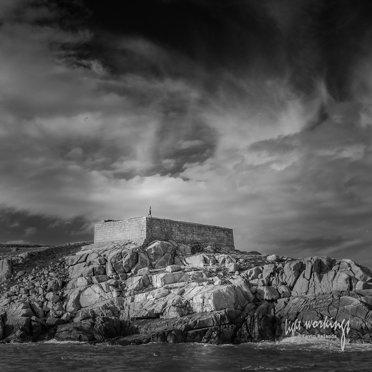
Week 11 (starting 22 December 2025): An overcast day in Glengarriff Harbour and the pursuit of “perfection”
I am very lucky to live in a very beautiful part of the world.
Landscape photographers tend to love beautiful sweeping vistas. More generally; photographers pursue “perfection” in their images. Frequently, even the most minor “imperfections” in a photo can render it worthless to them.
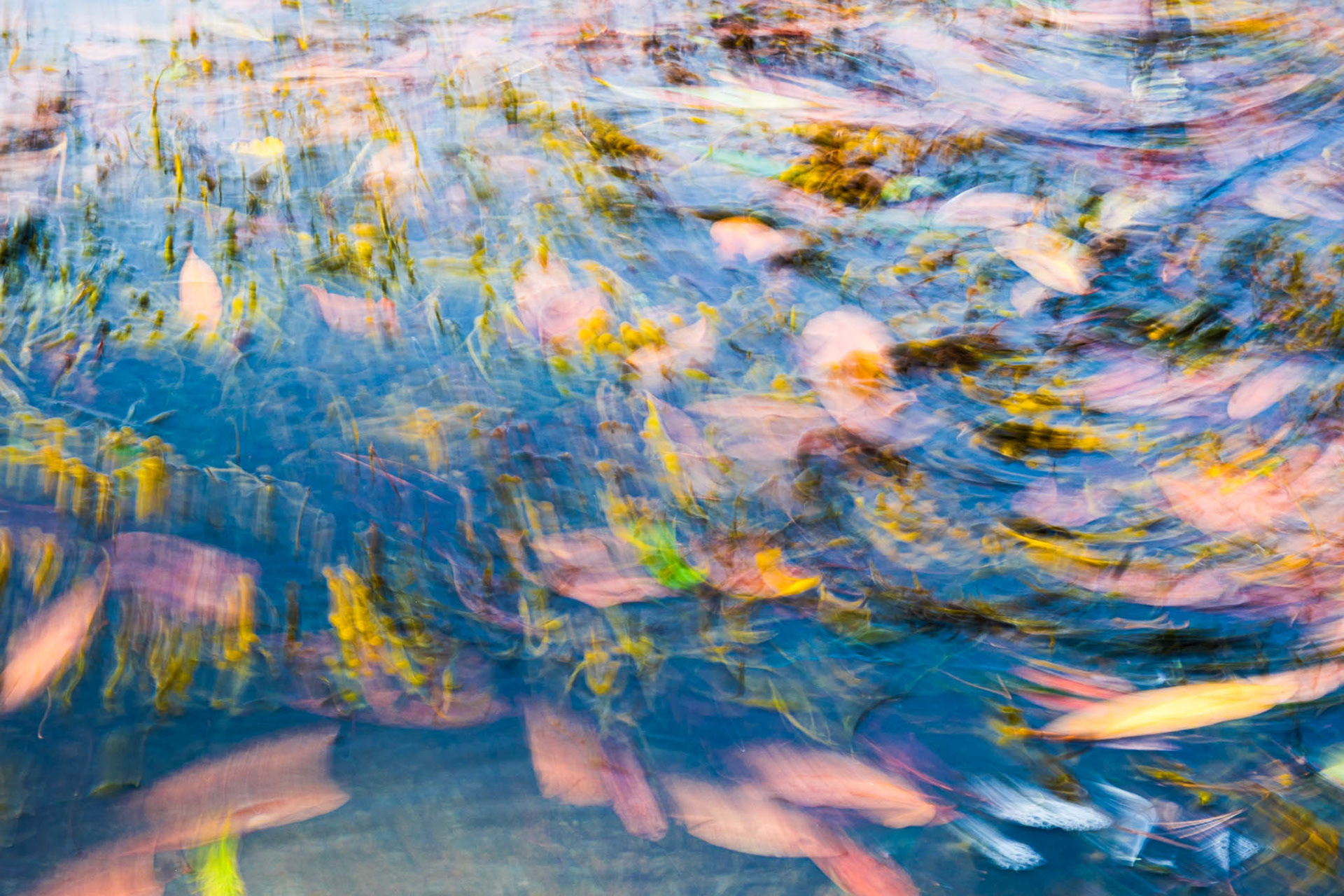
Recently I took my camera to the beautiful Glengarriff Harbour in West Cork. But the weather turned, the day became dull and overcast, and the light “flat”. I almost went home but instead turned to the water washing against the seawall. This is a photo of the swishing seaweed and the swirling leaves in the water at the bottom of a small concrete boat ramp. A little photo-editing brought out the colours and movement that were in the water. It was not the photo of the stunning vista that I had hoped to bring home.
The pursuit of “perfection” dominates not just photography but much of our lives. This obsession is driven in part by social media and business. The style of much of the visual imagery we now view is formulated with the growing assistance from artificial intelligence. It has become formulaic - “nice” but not that interesting. Many feel it is destroying creativity, dimishing our spirit and what it means to be human.
Some view this as part of a very large well-orchestrated marketting effort to create a pervasive sense of inadequacy within all of us. We are forced to constantly compare our simple lives and surroundings to this increasingly manufactured “perfection”. The perceived gap most of us feel between our circumstances and this manufactured “perfection” means that businesses can then step in and create commodities that they claim can fill this gap. While this unsatiable demand is destroying our planet, this commercially driven sense of inadequacy also leads many to overwhelming despondency; driving conflict and mental health problems in our communities.
Of course, none of this is new or a major revelation. This photo is not particularly memorable although it is a pleasant enough colour abstract. However; I love it because it is a timely reminder to me to enjoy the simpler, smaller, less “perfect” things in my world.
Week 10 (starting 15 December 2025): Mighty fortifications arising out of conflicts between Anglo Norman Kings and Barons and Irish High Kings
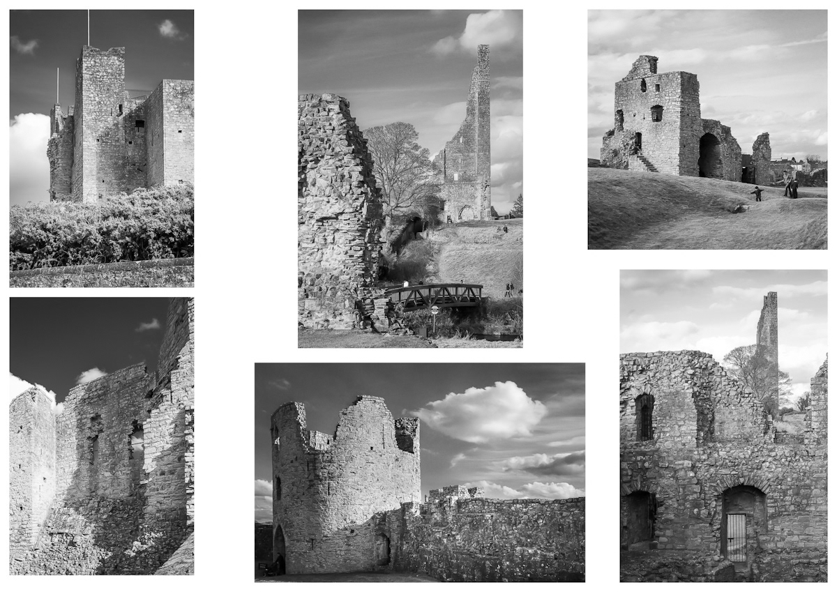
Trim Castle is the largest and best-preserved Anglo-Norman fortification in Ireland. This montage focuses on some of its key features; its full grandeur can only really be appreciated from a higher vantage point.
The town of Trim is an important crossing point of the River Boyne and by the fifth century an Irish chieftain's fort and an early monastery were already sited there. Shortly after the arrival of the Anglo-Normans in Ireland, King Henry II feared that one of his barons, Richard de Clare (“Strongbow”), might set up a rival Anglo-Norman kingdom in Ireland. To counter Strongbow's powerbase, King Henry II gave Meath to another of his barons, Hugh de Lacy, who decided to make Trim the centre of his newly acquired lordship.
Trim Castle was built in 1172 when de Lacy converted the existing ringfort into a wooden castle with a spiked stockade. In 1174, Rory O’Connor (the last High King of Ireland) attacked and destroyed the wooden castle. Recognising their vulnerabilty, de Lacy and his son Walter then began work that lasted several decades on what was to become the largest Anglo-Norman castle in Ireland. Initially a stone keep (a tower), this was remodeled and then surrounded by curtain walls and a moat. The wall, punctuated by several towers and a gatehouse, fortified an area of about 3 acres.
Most of the castle visible today was completed by 1220.
Week 9 (starting 8 December 2025): Branusmore, O’Brien’s Tower and Ireland’s most famous sea cliffs)
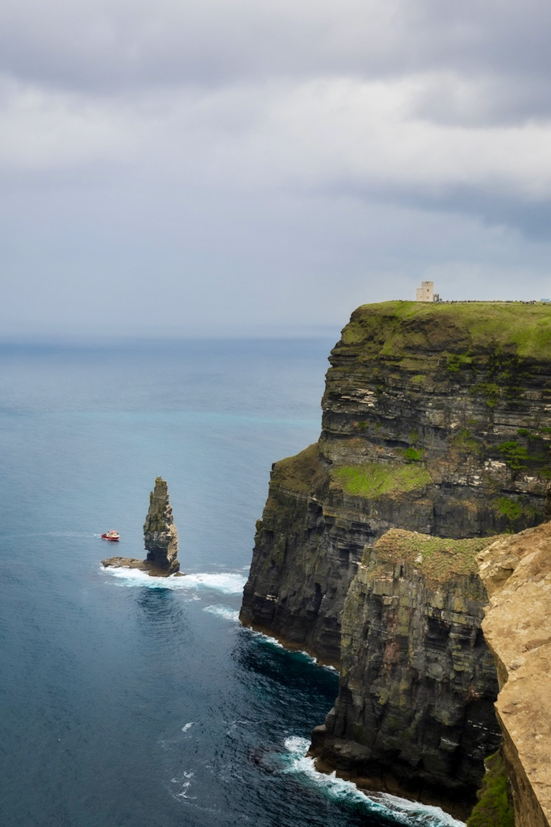
The Cliffs of Moher in West Clare are the most famous seacliffs in Ireland. They are thought to have been formed over 300 million years ago during the Carboniferous Period when Ireland was located close to the Equator. On the cliff faces you can see individual horizontal layers of rock or strata; the lighter coloured layers are sandstone, the darker layers are softer siltstone and shale. The sandstone layers are slightly more resistant to erosion but they cannot support their own weight for long and eventually crash into the sea below. Consequently; the cliff’s edges are somewhat unstable. The sea stack is called An Branán Mór, a 60 metre tall rock formation also known as O’Brien’s Stack. The sea stack was formed more recently than the cliffs. It was formed over millions of years by coastal erosion which wore away the surrounding rock, leaving An Branán Mór detached from the cliffs. Overlooking An Branán Mór is O’Brien’s Tower. Standing on the highest point of the Cliffs of Moher, it offers magnificent views south towards Hag’s Head and north towards Doolin. The Tower was built in 1835 by local landlord and MP Cornelius O’Brien who is reputed to have been a descendant of Brian Boru, the first High King of Ireland. It was built as an observation tower for the tourists and is said to have initially served as a teahouse. Below O’Brien’s Tower; fishing boats, tourist boats and recreational vessels share the beautifully wild Atlantic Ocean.
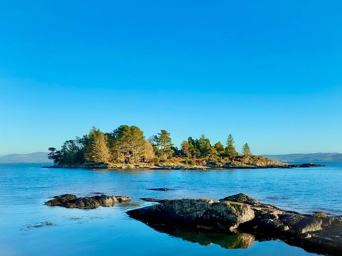
Garinish West, just off Zetland Pier on Beara Peninsula, is an island very close to shore ('Gar Inish' means 'near island' in Irish). Unlike the more well known Garinish in Glengarriff Harbour, Garinish West has been unpopulated except for a small holiday home built by Bernard Lovell in 1966, the famous English astronomer known as the “father of radio astronomy”. In the late 1950s, Lowell led the development of the world-famous telescope at Jodrell Bank in Cheshire, England. As it was being developed, crippling debts mounted and the project looked doomed; at one point Lowell was threatened with imprisonment! But when Russia launched the world’s first satellite and Jodrell Bank was able to track it, funding for the completion of the telescope was secured. Lovell wanted to keep things simple on Garinish West. His wife, Mary, described the island as their "heavenly retreat" and the couple and their children holidayed there often. Its isolation and clear unpolluted skies also allowed Lovell to gaze up at the celestial constellations and contemplate the mysteries of the cosmos. In post-humously released notes, Lovell claimed that, on a trip to a Soviet space facility in the Crimea, he was the victim of an attempted poisoning after he declined to work on the Soviet space programme. He said “it was as though all life had suddenly turned to dust and ashes." Fortunately, the illness lifted during a holiday to Garinish West when he "suddenly began to feel normal”. The true cause of his illness remains unknown.
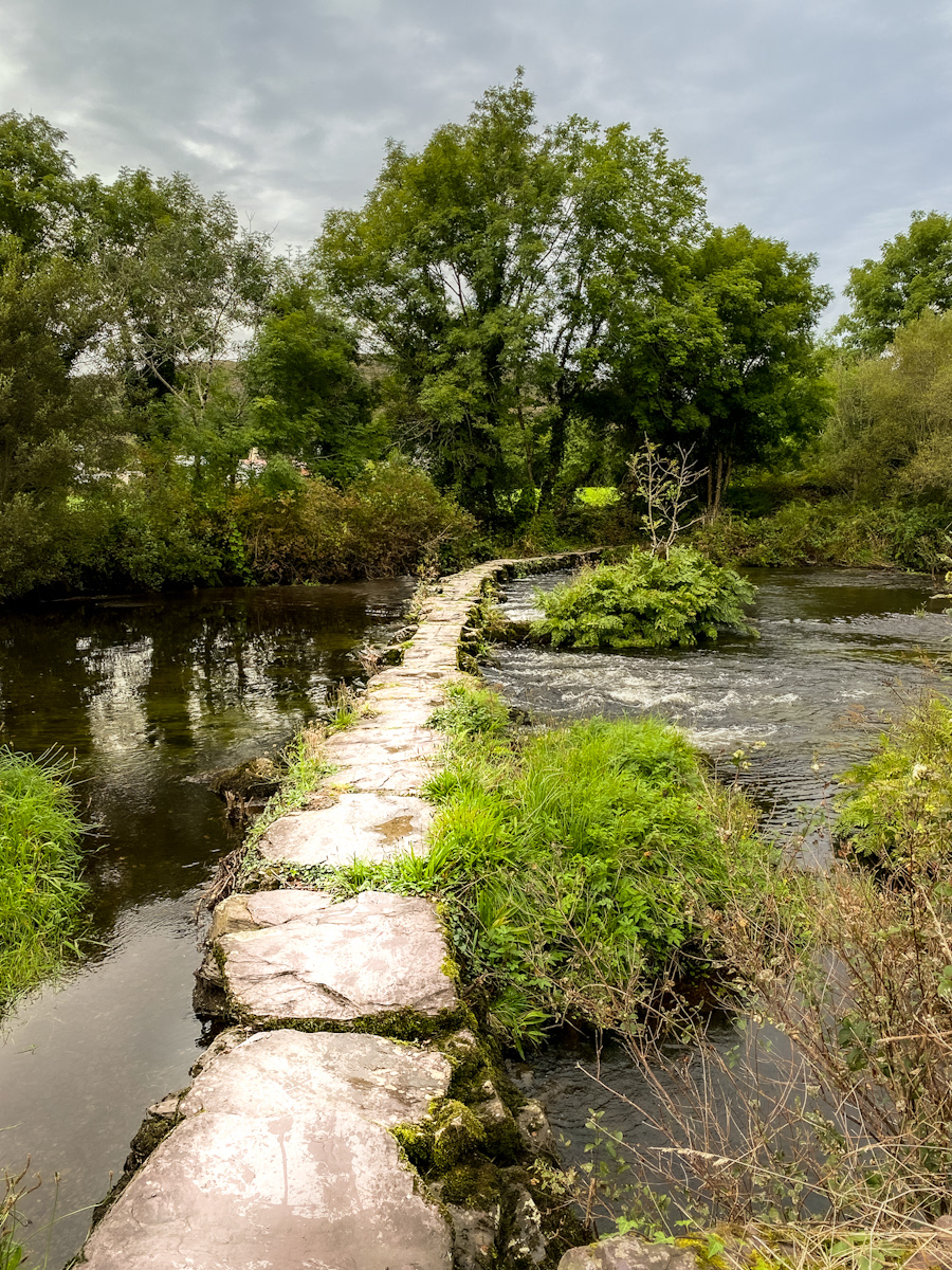
Week 7 starting 24 November 2025: A simple curved “clapper” bridge passing through Ballingeary in West Cork
This bridge, the “Ballingeary Stepping Stones”, crosses the River Lee as it runs eastward across Co Cork before passing through Cork City to meet the Celtic Sea. The bridge, said to be the longest “clapper” (stepping stones) bridges in Ireland, may date to the 17th century and is still used by locals and visitors. The bridge consists of eighteen large flat limestone slabs resting on rubble piers. A relatively unique feature is the bridge’s curve which follows the river’s path to cross it at its shallowest point; greatly reducing the number of stones needed and simplifying its construction. Rather than forcing a straight line against the river, the curved structure offers less resistance to the river’s water flow and means the bridge is less likely to be washed away during any of the many periods of high water and flood. The bridge is part of the Slí Gaeltacht Mhúscrai, a grand walking track which journeys through the heart of the Irish-speaking Gaeltacht region and some of the most scenic landscape in Co Cork. And amongst this walking track’s splendours, this photograph of a simple bridge that crosses the River Lee at its narrowest and shallowest point as it passes through the small village of Ballingeary.
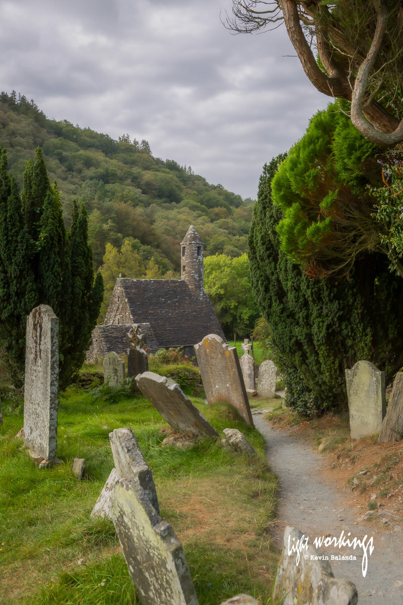
Week 6 starting 17 November 2025: St Kevin’s Kitchen in an ancient settlement at Glendalough in Co Wicklow
This photo of St. Kevin’s Chapel looks across an ancient graveyard at the monastic settlement of Glendalough (meaning “valley of two lakes”) in County Wicklow. The chapel is commonly known as “St. Kevin’s Kitchen” as the bell tower resembles a kitchen chimney and it was mistakenly believed that food was cooked there. The settlement offers a sense of seclusion and an opportunity for reflection amidst the beautiful glacial valley in which it was built. A medieval monastic settlement was founded in the 6th century by St Kevin (or Cóemgen). He led a simple life of prayer here and his fame as a holy man quickly spread across Europe. After his death in 618 AD the settlement flourished for over six centuries and became one of the most famous ecclesiastical centres in Europe. Although the destruction of the settlement by English forces in 1398 left it in ruins, it continues to this day as a place of pilgrimage. The buildings which survived probably date from between the 10th and 12th centuries and include a superb round tower, numerous medieval stone churches (St Kevin’s Chapel being the best preserved) and some decorated crosses. The present remains in Glendalough tell only a small part of its story. As well as being a religious centre, it was also a centre of learning and community life. In its heyday it included workshops, areas for manuscript writing and copying, guest houses, an infirmary, farm buildings and dwellings for both the monks and a large lay population.
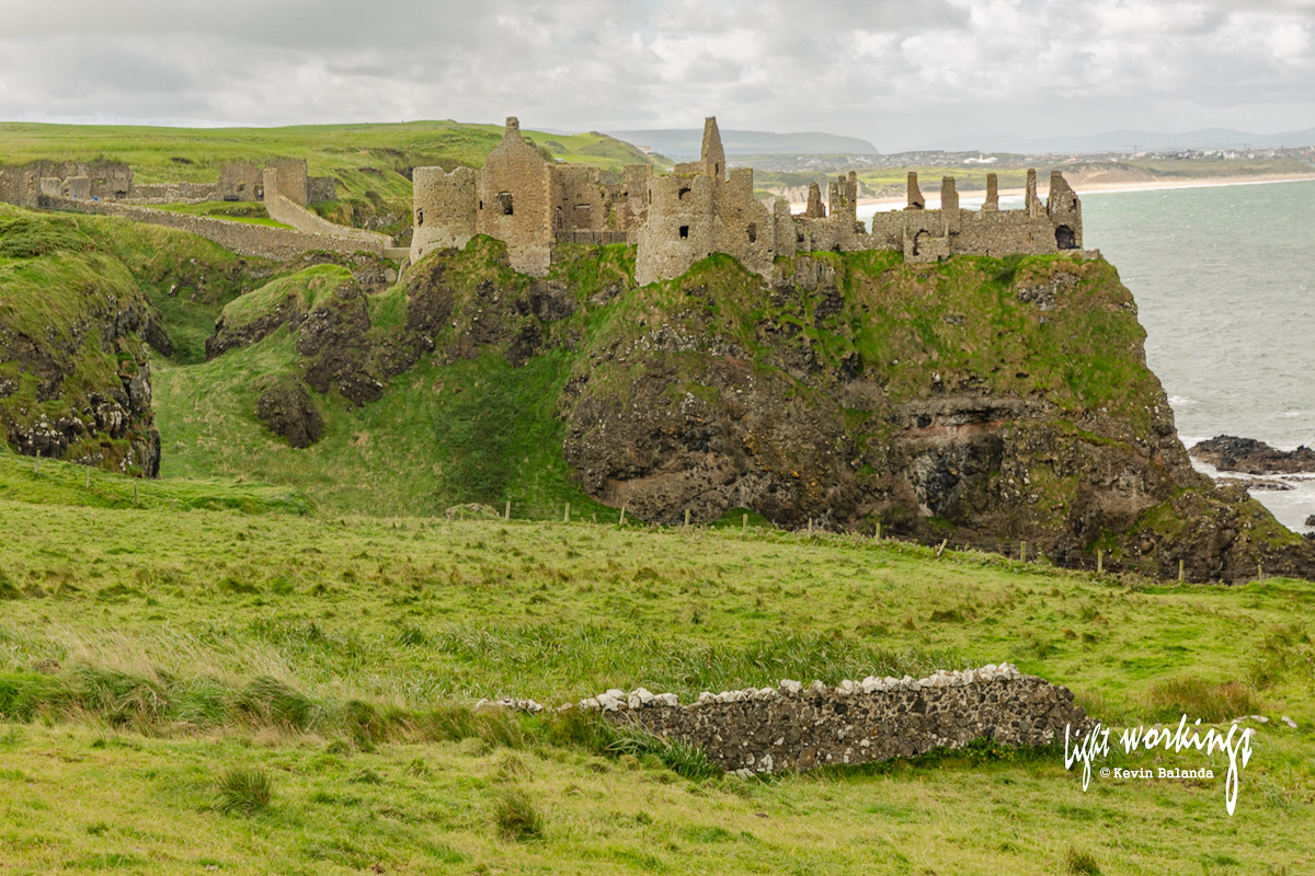
Week 5 starting 10 November 2025: A medieval castle, a violent feud, a tragic love story and a haunted banshee
Dunluce Castle is located at the end of the White Rocks cliffs on the Causeway Coast in Co Antrim. It has witnessed a violent feud between the McQuillans and MacDonnells that is intertwined with the tortured history of Ireland, Scotland and England. History places the castle in the hands of the McQuillans, in 1513, after they became Lords of the Route. They were driven out in 1584 by the MacDonnells, a branch of the Scottish MacDonald clan, after losing two bitter battles in the 1550s and 1580s. Salvage from the wreck of the Girona, part of a failed Spanish invasion of England, was used to restore the castle in 1588. Dunluce Castle was abandoned by the MacDonnells in 1690 after their impoverishment following the Battle of the Boyne. With such powerful histories come many tragic stories. Perhaps the most famous is the story of Maeve Roe, daughter of Lord McQuillan, who refused to marry her father’s chosen husband. As punishment, Maeve was locked into one of the castle’s towers until she mended her ways. She was in love with another man and, on one stormy night, her beloved launched a daring rescue but the pair were drowned in the wild seas below the castle. It is said she can still be seen keeping watch in the tower; her cries can be heard on stormy nights. The castle has a large place in our cultural history. In particular, in 1973 the castle appeared on iithe inner gatefold of the Led Zeppelin album Houses of the Holy.
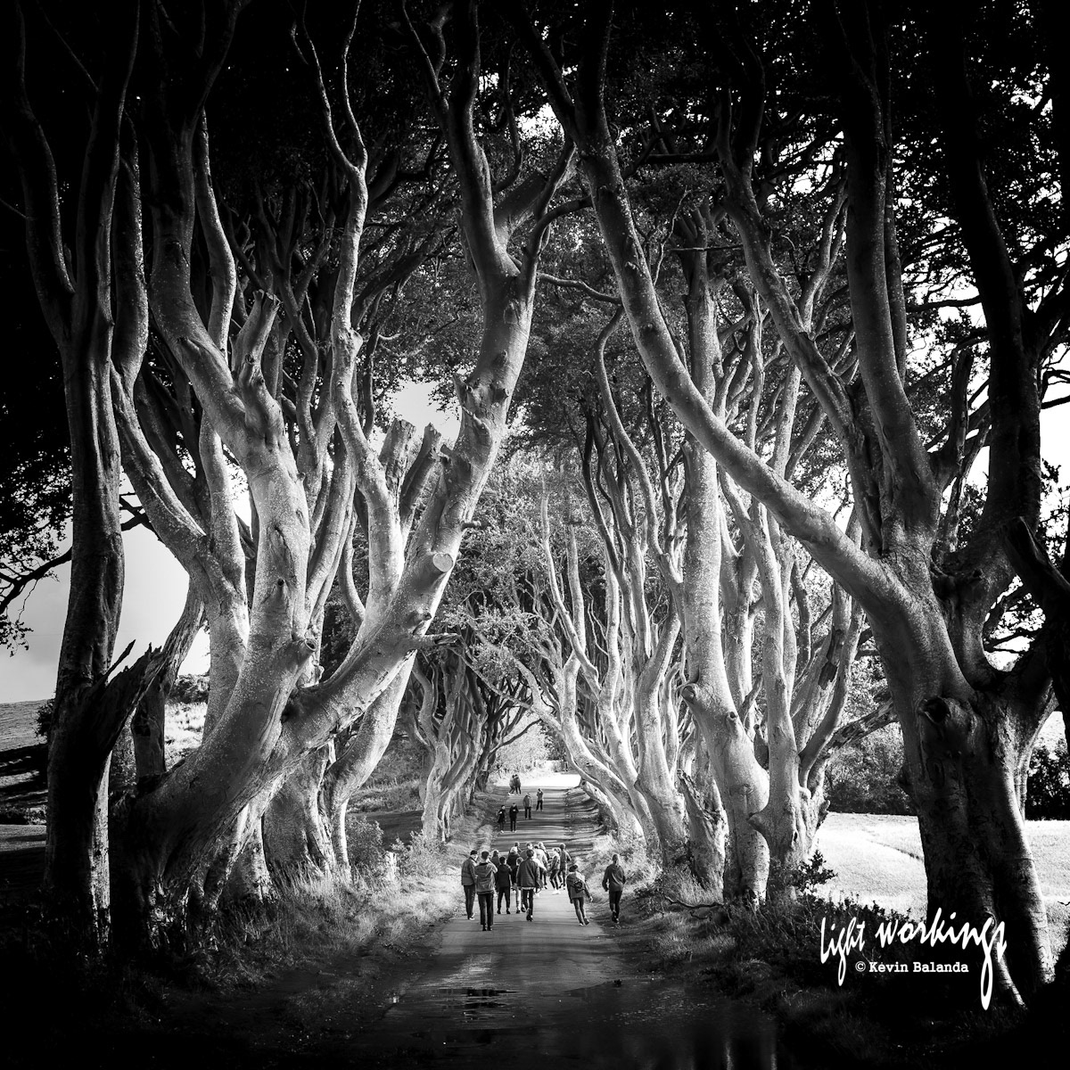
Week 4 starting 3 November 2025: Skipping down The Dark Hedges in Co Antrim where spectres wander
This is a photo of a beautiful avenue of ancient beech trees in Co Antrim, Northen Ireland. With it’s somewhat dark history, a black-and-white photograph seemed appropriate. The trees were planted by James Stuart around 1775 to create an imposing, and thus intimidating, approach to his family’s Georgian mansion, Gracehill House. Legend has it that the hedges are visited by a ghost called the “Grey Lady”; claimed to be either the spirit of James Stuart's daughter or one of the house's maids who died mysteriously centuries ago. Others believe she is a lost spirit from an abandoned nearby graveyard. Given this history, it is not surprising that the avenue features as the King’s Road in HBO's epic series “Game of Thrones. In the series, it is the major route connecting the major cities (Kings Landing in the south and The Wall in the north) in Westeros. Along with other filming locations in Co Antrim; it has become a major tourist attraction amongst “Games of Thrones” fans. Lesser known is that, although the trees still magnificent, many are at risk in heavy storms. Of the 150 trees originally planted, about 90 remained in 2016. As visitor numbers have increased, there have been concerns about vehicular traffic damaging the trees' roots as well as problems of graffiti. As their condition deteriorate, some trees have posed a danger to the public and have had to be felled. Like many beautiful spots in our world, tourism brings its own challenges to The Dark Hedges
Week 3 starting 27 October 2025: Dalkey Island and defending Ireland against feared and real threats
Dalkey, one of the wealthiest districts in South Dublin, was founded by the Vikings and nearby Collimore Harbour was a busy trading port. Close by, Dalkey Island is separated from the mainland by a narrow but deep channel called Dalkey Sound where ships could safely anchor, sheltered by the island, and unload their heavy cargo. The shallower Dublin Bay prevented direct shipments into Dublin City at the time. This photo tshows the gun battery on Dalkey Island. The gun battery and Martello Tower no. 9, constructed around 1805, were part of defence system built along the coast of Ireland to defend against a feared French invasion during the Napoleonic Wars. However, the French never returned after their failed attempted onvasions in the 1790s along the West coast of Ireland (see Part 1 photo). Eventually, Dalkey Island was abandoned by the military in 1886. A more real threat faced by Europe throughout its history was the bubonic plague. In fact; Colimore Harbour was one of the ports through which the devastating “Black Death” arrived on the east coast of Ireland in the summer of 1348. During one of its return to Ireland in the Middle Ages (in 1575 this time), tradition has it that the wealthier Dublin citizens used Dalkey Island as a place of refuge from this “Great Plague”. While this occasion was mentioned in Samuel Lewis’s 1837 “Topographical Dictionary of Ireland”; Dalkey Island probably played a similar role in earlier outbreaks of the plague. The desperate poor were left to take their chances on the mainland.
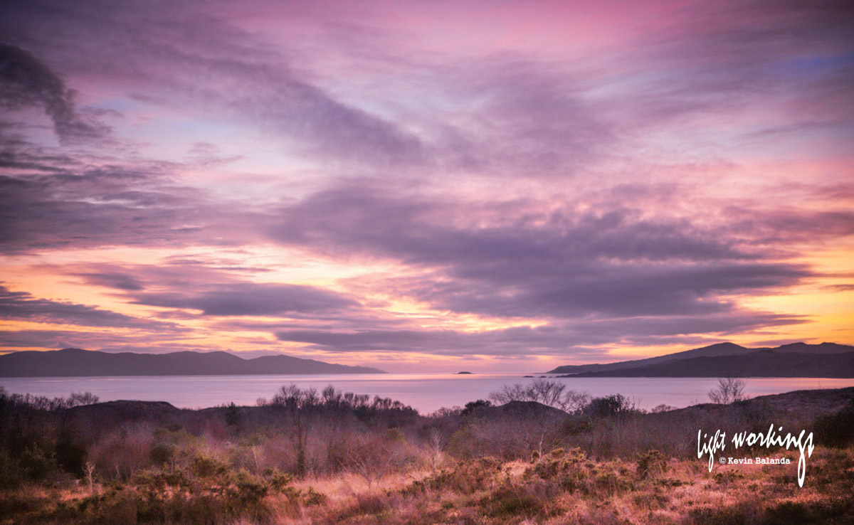
Week 2 starting 20 October 2025: Why the sunsets in West Cork, at the edge of Europe, are so inspiring
This photo was taken on a Winter’s evening looking over Bantry Bay out to the Atlantic Ocean. The Bay is framed by Sheep‘s Head Peninsula on the left and Beara Peninsula on the right. The conditions were perfect. During Winter the sun falls directly between the two peninsulas. On this evening the water was still; providing surfaces that reflected the sky's vibrant colors. The broken clouds in the sky dispersed the light and bounced it onto the shimmering water Later in the evening, halos form around the rugged mountains which eventually became silhouettes under a deeply coloured sky. West Cork in Ireland is blessed with a vast number of spectacular peninsulas, bays and smaller coves. North of Beara Peninsula are Iveragh and Dingle Peninsulas; to the south of Sheep’s Head Peninsula is Mizen Peninsula. Because of their location in the south-west of the island, the sun seems to move along the coastline. Facing the wild Atlantic Ocean; weather conditions are constantly changing and guarantee that no two sunsets are ever the same. From an aesthetic perspective, then, it seems that the West Cork coastline replicates many of the conditions needed for such uniquely beautiful and magical sunset experiences. For the meteorologically minded, moisture and fine dust particles in the lower atmosphere produce these violet displays.
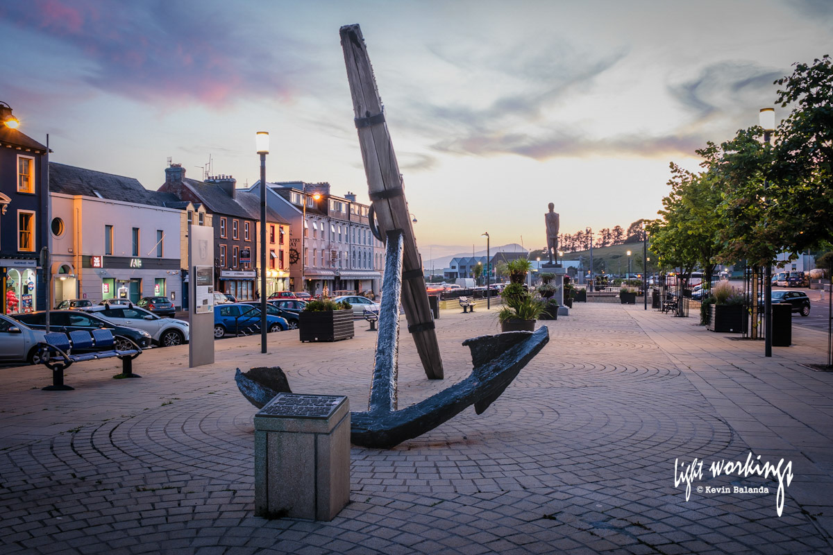
Week 1 starting 13 October 2025: A French warship, an Irish patriot and a town in West Cork
This anchor rests in Wolfe Tone Square in Bantry, West Cork and was salvaged from the French frigate “La Surveillante” which sunk in Bantry Bay. She was part of a failed French invasion of Ireland in December 1796. A year earlier the Irish patriot, Theobald Wolfe Tone, had joined the French Court to form an alliance with France against the English reign in Ireland. Eventually, in December 1796, a French fleet consisting of over forty ships and around 15,000 troops set sail for Ireland. Its goal was to rendevous with Irish rebels at Bantry and spark a rebellion against British rule in Ireland. However; the fleet faced wild storms and seas and, although some ships reached Bantry Bay, the battered fleet received orders to return to France after a few days. In 1798 the French tried again and landed an expeditionary force on the west coast of Ireland but this also ended in failure. Many consider Wolfe Tone to be the founder of Irish Republican Nationalism and this square named after him contains his statue facing out to Bantry Bay. The failed French invasions were key milestones in the Irish fight for independence.